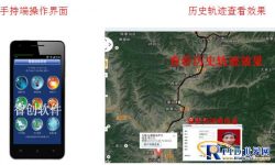
GPS intelligent inspection system for pilot forest rangers in Qinyuan, Shanxi Province
[ad_1]
1. Overview of GPS Forest Protection Inspection System
This system is to provide the forestry protection department with a patrol inspection management system for fire prevention, theft prevention, and insect disaster prevention. Through GPS global positioning technology and GIS geographic information, it can implement strict and standardized management of forest rangers’ fire prevention, theft prevention, and insect disaster prevention work. Automatically or manually report information through GPS inspection device (Android mobile phone), and support photo and video recording. It can timely feedback various events found during inspection to the management center, and indicate the accurate latitude and longitude. In the event of endangering forest management In the event of personal and life safety emergencies, an emergency distress signal can be sent to the alarm with one key, indicating the accurate latitude and longitude, and providing the rescuers with an accurate geographic location. And it can complete powerful functions such as the forestry bureau’s self-defined inspection area, inspection route, inspection time, inspection personnel, shift plan, network query, remote management and remote transmission. It is easy to use and can be used without any operation. Complete the forest ranger inspection.
In accordance with the national guidelines of “rejuvenating forests with science and technology”, Qinyuan County Forestry Bureau has introduced GPS technology in forest protection work for forest management and protection personnel based on the actual situation. “GPS Forest Protection Personnel Intelligent Inspection System”. The system is an intelligent inspection system based on the application of GPS global positioning technology and GIS geographic information technology, with Android smart phones as the platform, and data communication through the GSM public network. It can automatically or manually report information through the GPS inspection device, and support photos and videos. It can timely feedback various events found during the inspection process to the management center, and indicate the accurate latitude and longitude. In the event of life safety emergencies, an emergency distress signal can be sent with one key, indicating the accurate latitude and longitude, and providing the rescuers with an accurate geographic location. The use of this system can provide timely feedback on forest fires, insect disasters, and deforestation events, and also provide a great guarantee for protecting the personal safety of forest managers.

2. Features of GPS Forest Protection Inspection System
1. Automatically receive positioning information, and there is no need to arrange points at the work site, so it can save huge on-site engineering construction and maintenance costs.
2. The GPS positioning inspection management system uses the existing mature GSM public network for data communication, without the need to build a communication network, and there is no daily maintenance of the communication network, so that the cost of network construction is low.
3. It has the function of automatically uploading information, which can upload the current location and inspection situation in real time.
[ad_2]


