Application case of wireless sensor network in field measurement
[ad_1]
In the field of industrial measurement, long-term, large-scale, multi-channel data measurement systems are often required. In the field of field environmental monitoring, due to the special circumstances of environmental conditions, the monitoring system is often difficult to deploy effectively due to the existence of factors such as power supply and long-distance wiring. The wireless sensor network is especially suitable for field measurement in the industrial field due to its low power consumption, self-organizing routing, and no wiring.
This article will introduce a case of a wireless sensor network deployed in a coastal city in southern my country. The system can meet the needs of many industrial measurements after a few modifications.
The city has a lot of mountainous landforms and a large population of urban residents, which requires a high utilization rate of land, so a large number of buildings and roads are located near the mountains. The rainfall in this area is high all the year round, especially in the rainy season in summer, there will be a lot of precipitation. Unstable mountainous landforms are prone to landslides after being eroded by rain, posing a huge threat to the safety of residents’ lives and property.
Local authorities have tried to deploy multiple sets of wired monitoring networks to monitor and warn of landslides. However, because the monitoring areas are often inaccessible mountains, lack of roads, and restrictions on field wiring and power supply, the deployment of wired systems is limited. It’s very difficult to get up. In addition, the wired method often adopts the method of deploying Datalogger nearby to collect data, which requires a special person to go to the monitoring point to download data regularly, and the system cannot obtain real-time data, and the flexibility is poor.
In this regard, after many exchanges with geographic monitoring experts and several field visits, Crossbow proposed a complete wireless solution for landslide monitoring based on wireless sensor networks.
Basic Measurement Principles
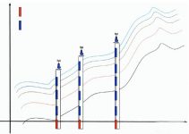
The monitoring of landslides mainly relies on the role of two sensors: liquid level sensor and inclination sensor. In the area where the mountain is prone to danger, multiple holes are vertically arranged along the trend of the mountain, as shown in Figure 1. Each hole will deploy a liquid level sensor at the bottom and several inclination sensors at different depths. Since landslides in this area are mainly caused by rain erosion, the depth of the groundwater table is the first indicator of landslide risk. This data is collected by a liquid level sensor deployed at the bottom of the hole and sent via a wireless network.

The movement of the mountain can be monitored by the inclination sensor. The mountain is often composed of multiple layers of soil or rock. Due to the different physical composition and erosion degree, the movement speed is different between different layers. When this phenomenon occurs, tilt sensors deployed at different depths will return different tilt data, as shown in Figure 2. After the wireless network obtains the data of each inclination sensor, and through data fusion processing, professionals can judge the trend and intensity of the landslide and judge its threat.

The overall system architecture is shown in Figure 3. The products Crossbow used in this project include the new Mote node IRIS, MDA300 data acquisition board, and Stargate base station; the MoteWorksTM software environment includes Xmesh protocol stack (IEEE802.15.4 compatible), Xserver middleware and MoteWeb visualization management platform.

[ad_2]


