Hunan Huayuan Power Line and Facilities GPS Inspection Management System Project
[ad_1]
The first plan of Huayuan Electric Power Co., Ltd. is mainly to use GPS inspection personnel to collect the distribution positions of transmission lines, poles, line towers, high-voltage towers and other equipment on site, and at the same time, to collect the critical lines found during the collection process. The hidden dangers of safe operation, illegal buildings, theft and other surrounding environments are collected on-site. It is convenient for the command and dispatch center to grasp the latest GIS information and formulate the daily inspection work and maintenance construction plan in the later period. After 2 months of use, the results have exceeded the customer’s expectations, and they are very satisfied with the product.
After the line patrol personnel use it: it is very simple to use, just take a photo with the mobile phone and the work is done. We don’t need to worry about anything. When we return to the office, all the photos will be uploaded automatically, without considering the traffic cost, so we take more on-site photos. It takes several days for us to patrol outside each time. If there is any danger, just click the alarm, and the command center will immediately know where we are, effectively ensuring our own safety.
After the command and dispatch center is used: sitting in the office, you can keep abreast of the work of the inspectors, the operation of transmission lines and facilities, and the changes in the surrounding environment; ordinary line inspectors can collect the distribution of transmission lines and auxiliary facilities without having to Look at the old drawings, the information is old, and the workload is heavy. Now you only need to go through the line inspection staff once. You can grasp the latest distribution of transmission lines and facilities, and it is convenient to formulate future inspection plans, maintenance, and construction plans. , truly enter the information and scientific management mode, effectively improve the work efficiency and the safe operation of the transmission line, and better serve the people.
Use effect display:
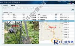
1. The location, name, surrounding environment, collection time, personnel and other server-side viewing effects of equipment coordinate points:
2. Viewing and statistics of images, coordinates and positions of equipment hidden dangers and theft, etc., to facilitate the formulation of maintenance and construction plans.

[ad_2]


