Design of wireless positioning system ZPOS based on ZigBee
[ad_1]
Technology Brief
ZigBee technology, ZigBee is an emerging short-distance, low-rate wireless network technology, which is currently widely used in wireless sensor networks and other occasions. ZigBee devices have low power consumption and low cost, so it can ensure that ZigBee-based positioning systems can achieve long-term accurate positioning at a lower price. In addition, due to the support of ZigBee network integration for mobile ad hoc networks, the construction of the entire system is flexible, the amount of infrastructure construction is small, and the rapid deployment of positioning systems can be achieved in various complex environments.
Design of Z-Pos Underground Positioning System
Z-Pos product ideas
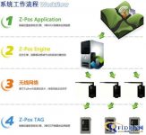
Z-Pos is a wireless intelligent positioning system developed and launched by Hangzhou Chenlin Company in a timely manner based on the good development prospects of domestic wireless networks and real-time accurate positioning of a large number of potential applications in a certain area (indoor and outdoor). Its main principle is to use the wireless network and its many fixed access point devices (AP) to monitor the signal and time delay of the mobile node Z-Pos TAG in the network in real time, in the Z-Pos Engine (own intellectual property) After a series of calculations, comparisons, and corrections, the relative and absolute position information of the tracked object Z-Pos TAG is obtained.
Principles of Z-Pos System
First, place a certain number of Z-POS base stations/base stations in underground areas and tunnels according to the actual needs of the enterprise. The placement should be based on the specific conditions of the site (such as important locations such as main underground tunnels, intersections, and necessary roads). According to the actual situation of the roadway, place a base station every 50-80 meters.
Then wear a Z-POS TAG (location tag) for each downhole personnel. When the downhole personnel enter the well, as long as they are within the coverage of the downhole network at any point at any time, the base station can collect the location tag signal and upload it to the background server. After the positioning engine and other business processing, the specific label and representative information (such as: personnel, location, time) can be obtained, and it can be dynamically displayed (real-time) on the large screen or computer of the monitoring center, and backed up. The personnel on the well can know the status of the personnel on the well at any time.
Managers can also view a certain area according to the distribution diagram on the large screen or on the computer, and the computer will then count and display the personnel in this area. The manager can observe the real-time position of the underground staff in real time, and realize the positioning of the underground personnel. In addition, once an accident occurs in the mine, the personnel at the accident site can be found immediately based on the personnel location distribution information in the computer, so as to help rescuers accurately and quickly rescue the trapped personnel.
Once an emergency occurs downhole, underground personnel can send out an alarm through the positioning tag carried. The underground personnel only need to press the emergency alarm button on the label to give an alarm, and the monitoring room on the well will immediately give text and sound and light reminders.
ZPOS system workflow

Introduction to the main functions of the system
The software system adopts B/S architecture, which can be remotely accessed and managed. The database supports Mysql, ORACLE, etc. The main functions are as follows:
System management configuration
Modification of various system parameters such as account, password, tag personnel correspondence, alarm mode setting modification, etc.; distribution management of login permissions for different accounts.
Real-time location of miners
The structural layout of each well layer and each roadway is displayed in an intuitive way. When the staff in the mine carrying the tag walks within the coverage of the positioning base station, the monitoring room screen can be dynamically displayed in real time as they move. The corresponding icon position.
Miners urgently ask for help
There is an emergency help button on each location tag. When needed, the wearer can press and hold the emergency help button on the tag for 3 seconds, and the monitoring room will be able to learn who sent the alarm message in the first time.
Emergency evacuation of the whole well
When there is a special situation and the ground monitoring center needs to dispatch all underground workers to withdraw to the ground in time, the system provides an emergency retreat button. Once the emergency retreat function is activated, all areas covered by the network of this system will have audible and visual alarms.
Historical track playback
For any label, its historical walking track can be traced. As long as a start and end time period is selected, the system will automatically retrieve the place it passed during that time period and form a playback animation.
In addition, the system also supports setting a certain time point such as 2011-1-5 17:00:00, the location map of all work labels at this moment, in order to understand the distribution of the entire mine staff.
In and out of attendance statistics
Various statistical analysis of attendance can be carried out according to time period, team, etc., and support a variety of graphic modes
Real-time monitoring of underground environment
Each downhole positioning base station can also load the environment acquisition sensor function according to actual needs, and transmit the surrounding environmental parameters such as temperature, humidity, carbon monoxide concentration, etc. to the monitoring center platform through its own wireless network in real time. If an alarm valve is set Value, the monitoring screen will give warning prompts for the over-standard area in different levels.
Network monitoring management
For the entire underground wireless network, the system provides real-time monitoring of network quality, node performance and other functions, and it is marked with a map, which is convenient for real-time management and maintenance.
[ad_2]


