Solutions for speed limit and automatic stop reporting of vehicles on curved roads in tourist attractions
[ad_1]
one.Overview
In most of the well-known tourist resorts in my country, thousands of pinnacles have been set aside in the scenic area. Hundreds of winding streams can be described as merging peaks, forests, caves, lakes, and waterfalls. Dangers in one, “five steps a scene, ten steps a heavy sky”, constitute a beautiful picture scroll. However, this has also caused the winding roads in the scenic area, with many sharp bends, and there are great hidden dangers in driving. In order to ensure the safety of the lives of tourists, to maintain a good tourist image of the scenic spot, and to prevent the occurrence of safety accidents in the scenic spot.
At present, some scenic spots have invested more than 10 million in the construction of “GPS/GPRS-based vehicle management system” and “station video monitoring system”. Due to the technical limitations of GPS (refresh rate: 1 time/second, accuracy: ≤15 meters), it is impossible to accurately measure the speed of the vehicle in the curve, so it is impossible to accurately identify the driver’s speeding behavior, and it is impossible to criticize and educate the driver. Punishment. In addition, the vehicle lacks automatic stop reporting and pre-driving reminder functions. It often happens that tourists get off the wrong station, stand unsteadily and fall and are injured, causing many driver and passenger disputes and complaints.
The solutions for speed limit and automatic stop reporting of vehicles on curves in tourist attractions can solve the following problems:
1. Accurately measure the speed of the vehicle in the curve, realize the speeding reminder, and the alarm function;
2. Reminder function before driving to prevent tourists from standing unsteady and falling, and avoid driver and passenger disputes and complaints;
3. Automatic stop reporting function to prevent passengers from getting off the wrong stop;
4. Positioning function, real-time vehicle positioning, effective scheduling of vehicles.
two.System solutions
2.1 Achieve “accurately measuring the speed of the vehicle in a curve”

1. Install a JRF253CD desktop card reader on each car. A GPRS communication module is installed inside the JRF253CD reader, which can communicate with the system in real time; there is also a voice module inside to complete the voice prompt function, and a GPS module can be added;
2. Install multiple JRF240CD active electronic tags at the speed limit position, and install JRF240CD active electronic tags at each station;
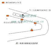
The label AB in Figure 1 is used to predict the speed function. When the vehicle passes two points AB, if there is speeding, the system will alert the driver with a “click, click, click” sound.
The label CD in Figure 1 is used for the speed measurement function. When the vehicle passes two points on the CD, if there is an overspeed, the system will sound a “click, click, click” alarm, and the alarm information is transmitted through the background of GPRS as the basis for fines.
2.2 Safety warning reminder before starting the vehicle
Install a reminder button on the card reader. The driver presses this button before driving, the device reminds and the passengers pay attention.
2.3 Automatic station announcement
At each platform, electronic tags are installed, and when the bus arrives at the platform, the platform name is automatically recognized to realize the automatic station announcement function.
2.4 Vehicle positioning
The GPS module is added to the JRF253CD card reader to complete the real-time positioning of the vehicle, and the dispatcher can fully grasp the operation of the entire vehicle through the map.
three.Product index
3.1. JRF253CD desktop card reader requirements:
Card reading function;
Speed measurement function;
GPRS communication function;
Storage function;
Voice automatic playback function;
Voice manual playback function;
Save MP3 voice files;
Optional GPS function;
3.2 JRF240CD active electronic label
Ability to read and write
Able to distinguish speed limit tags and station tags;
Able to write ground code;
Kilometer serial number;
Kilometer mark
Information such as the speed limit;
3.3 System software
3.3.1 Acquisition software
GPRS communication module;
data collection;
Inquire;
Report
3.3.2 WEB query report software
Inquire;
Report
statistics;
Four.Key technology
1.Accuracy of speed measurement
V = LAB/ TAB
LAB refers to the distance the vehicle passes through AB in the figure;
TAB refers to the time when the vehicle passes AB in the figure;
If V is greater than the specified speed, the system records the vehicle position, current driving speed, and current time.
How to improve system accuracy
Because the multipath effect of wireless communication is relatively common, when reading tags, it does not happen completely according to the theoretical situation, so these problems must be considered from the software. As shown in Figure 3, the card reader on the vehicle may read the card for the first time at A1, may read the card for the first time at A2, and may read the card for the first time at A3. How to determine that the vehicle passes A Where is the point?
five.Product List

Based on JAVS-Active RFID technology, Shenzhen Jiaweisi Technology has proposed a solution for speed limit and automatic stop reporting of vehicles on curved roads in tourist attractions to prevent safety accidents in scenic spots and improve service quality.
[ad_2]


