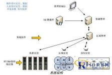
LocateSys™ infrared positioning system
[ad_1]
System Overview
LocateSysTM infrared positioning system adopts a positioning system that combines infrared and wireless positioning. The system can achieve three-level positioning of cabinets, rooms and areas, and can be used for enterprise asset management and environmental monitoring. The system consists of four parts: location tag, infrared locator, location card reader and location management software. in:
●The location tag is powered by a button battery, and the power supply is up to 3-5 years, providing tags of different forms and purposes;
●The infrared locator acts on the tag with infrared transmitter for positioning;
●The positioning card reader acts on all tags in the area through the 433MHz wireless signal;
●The positioning management software can manage the entire positioning system through a browser, display the status of all tags in the positioning area in real time, and set management rules as required; the system provides APIs and supports secondary development.
●The basic structure of a typical system is shown in the figure:

system structure
Features and indicators
The characteristics of LocateSysTM infrared positioning system are:
●Large working distance: the effective distance can reach 100 meters;
●High positioning accuracy: through the combination of infrared and wireless technology, close to 100% accurate positioning is achieved;
●Real-time: The system provides real-time label status and realizes fully automatic management;
●Multi-occasion application: According to different locators, cabinet-level and room-level positioning can be realized;
●Cellular expansion: It can be expanded in a manner similar to that of a mobile communication network to expand the coverage area;
●Simple deployment: The system only needs to connect the card reader to the server, and it also supports wireless networking;
●Open data interface: open API;
●Multiple choices: According to different applications, you can choose different labels;
Performance indicators of LocateSysTM infrared positioning system:
Wireless communication frequency band: 433MHz public frequency band;
Label sending frequency: 2-10 seconds;
Label use time: generally 3 years.
Positioning data delay: <10 seconds;
Card reader coverage: the communication distance between the sensor and the tag is 100 meters;
LocateSysTM infrared positioning system management software
The positioning management software is used to set up label area division, alarm and other functions according to different management needs, and display the status of the label in real time.
Application area
LocateSysTM infrared positioning system application areas: asset management and environmental monitoring.
※Asset management: real-time positioning and inventory of important assets in areas such as computer rooms, offices, and warehouses;
※Environmental monitoring: real-time monitoring of the environment in computer rooms, offices, warehouses, etc., such as: temperature, humidity, smoke, door opening and closing, fluid, power monitoring, etc.
[ad_2]


