Elderly care indoor positioning system solution
[ad_1]
1 background
With the development of the economy and the progress of the aging trend of the population, more and more institutions of the nature such as nursing homes and apartments for the elderly have come into our sight. Since nursing homes are generally distributed in a relatively closed area, consisting of walls, courtyards, and buildings with various functions, this type of regional pattern generally has a relatively large area. Under normal circumstances, the elderly spend most of their time in this building area. To determine the location of the elderly in the nursing home in real time and provide timely services to them, especially when the elderly are in an emergency and require assistance from the hospital, “positioning” is even more important. Whenever the elderly is in danger, they can quickly locate the location, and automatically call the police at the first time, and the service personnel of all positions rush to the scene immediately. The personnel positioning monitoring system brings the indoor and outdoor areas of the entire community into the scope of real-time wireless network monitoring. As a result, the safety management of the elderly in nursing homes has become an issue of increasing concern to society.
RTLS (Real-time Positioning System) plays an important role in the monitoring of the elderly, and can carry out real-time positioning and information collection for the elderly.
2 System overview
The main focus of the elderly care indoor positioning system is the elderly, and it also involves the management of nursing staff and managers in practice. In response to this demand, a set of management system combining software and hardware has been specially designed and developed. The management work in nursing homes can use lower cost and time cost, collect and sort information, and staff can manage the daily life of the elderly. In the event of an unexpected special situation, the system will promptly initiate an alarm, and the staff can respond as quickly as possible based on this, so as to provide protection for the life safety and healthy and comfortable life of the elderly.The whole system is integrated RFID Technology, wireless transmission, communication and other technologies, combined with elderly care applications, incorporate new technical information concepts. The software platform integrates the functional applications of elderly care management. The specific functions are the management of basic personnel information, location positioning, monitoring and alarming, information query, data maintenance, etc., to achieve the informatization and intelligentization of centralized elderly care services and management.
3 System design and implementation
3.1 System composition

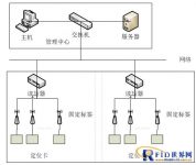
The system consists of three parts, namely the information collection end, the server end and the client end:
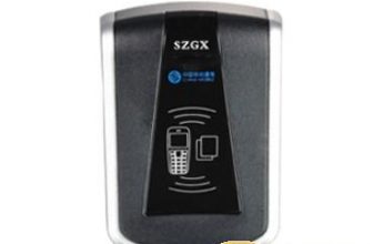
1. Data acquisition end: The acquisition end hardware includes readers, fixed tags, and cards.
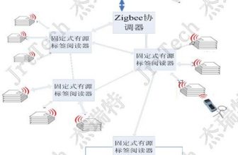
The positioning card periodically sends a wireless signal (wireless signal includes positioning information, various alarm information, etc.) to the fixed tag. The reader is responsible for real-time collection of positioning card information and uploads it to the network. The upper-level software analyzes the card location to achieve Positioning, alarm and other functions.
2. Server side: The server side installs analysis programs and databases, which are mainly used to store, analyze and process the data reported by the data collection side. These processing include: personnel identity information, card information, location information, abnormal alarm information, equipment link information, Equipment low battery information, etc.
3. Client: The client mainly uses basic information entry and data interface display. The entered information includes basic information of personnel and positioning cards, base station information, and basic information of maps; the displayed information includes personnel icons and location display, various alarm information, various query results display, various classification statistics information display, etc.
The data collection terminal, server terminal, and client terminal jointly constitute the personnel positioning management system. Through the organic combination of the three parts, various data uploads, data analysis and processing, and data display are realized, thereby realizing real-time and comprehensive personnel monitoring.
3.2 System Architecture
The elderly care indoor positioning system is a three-tier structure system based on a lightweight MySQL database and a component-based development. The three-tier structure is:
Database: Management personnel and equipment information data.
Middle layer: used for system settings such as adding, modifying, and deleting personnel and equipment information.
Presentation layer: management tasks such as user’s daily query and positioning.
3.3 Basic principles of the system
The elderly care indoor positioning system is based on RFID technology and uses RSSI signal field strength measurement algorithm with an accuracy of 5m.

First, place a certain number of positioning base stations according to the specific conditions of the area. Personnel carry a positioning card. When the person enters the area, the fixed tag receives the information of the card, and transmits the information to the reader, and then uploads it to the server. The coordinates of the person on the map can be calculated by the system software. , And displayed on the map as a person icon + name.
Ranging principle:
The distance between the positioning card and the positioning base station is proportional to the signal strength. When the positioning card is closer to the fixed tag, the signal received by the fixed tag is stronger, and vice versa; the system calculates according to the functional relationship between distance and signal strength Draw the distance between the positioning card and the fixed label.
The base stations around the positioning card periodically perform ranging operations with the positioning tag. The server combines the measured data and the coordinate information of the fixed tag to calculate the coordinates of the positioning card, thereby determining the specific location of the positioning tag and realizing positioning.

3.4 Positioning algorithm
System positioning is divided into regional positioning, linear positioning and plane positioning. Regional positioning mainly realizes the identification of persons within the signal coverage of the fixed tag. When the positioning tag enters the area, the fixed tag receives the tag information, and when the signal strength reaches the set value Value, the system judges that the label is in the area; straight line positioning is for longer areas, such as roads, etc., according to the strength of the signal received by the fixed label, the system calculates the distance between the label and the two fixed labels, and then determines its position; plane The positioning is mainly aimed at the positioning of larger areas. A certain number of fixed labels are placed in the area. Generally, four fixed labels form a positioning area around the generally laid area. The strength of the positioning signal is calculated from the distance between the label and the fixed label. According to the coordinate information of the fixed label, the X and Y coordinates of the label in this area are calculated to realize the positioning of the label.
3.4.1 Principles of regional positioning
As shown in the figure, each fixed tag has a certain signal coverage area. When the mobile tag enters the identification range of base station A, the base station can receive the information sent by the mobile tag, and then know the location of the area where the tag is located at this time.
The schematic diagram is as follows:

3.4.2 Principle of linear positioning
As shown in the figure below: When a person carries a mobile tag between two fixed tags (full signal coverage), the tag is periodically tested with the fixed tag, and the system moves the position of the tag according to the ranging result.

3.4.3 Principle of Plane Positioning
As shown in the figure, A, B, C, and D are fixed tags. When a person carries a positioning tag into the four fixed tags, the tags periodically perform distance measurement with the fixed tags. The system calculates according to the ranging results and the coordinate information of the base station. Output the coordinate information of the positioning label.

3.5 Equipment layout rules
[ad_2]


