[ad_1]
1. System Overview
In order to standardize the access management of visitors from units and prevent unsafe factors caused by visitors, based on the frequent and complex features of office buildings, enterprises and institutions, the location management system for visitors has been developed.
Through the visitor card, the system realizes the functions of locating visitor, track record, warning of restricted area, etc., and can be bound with personal identity information, so as to conduct scientific and effective management of visitors.
Visitors can simply register to complete the entry of identity information, and issue visiting cards for real-time online management.
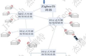
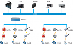
2. System structure diagram

The system consists of a host, a switch, a base station control unit, a base station, and a positioning card. The positioning card is bound to personnel information and periodically sends wireless information to the base station. The base station collects the information and uploads it to the host. The host analyzes according to a specific algorithm The various data of the middle positioning card, such as the coordinates of the positioning card, the status of the card, each alarm and other data, so that the various functions of the system can be realized.
3. Main functions of the system
3.1 Real-time personnel positioning
It can locate the current location of the personnel in real time, which is convenient for observing their on-the-job situation or searching.
3.2 Personnel track playback
The system can display the historical travel route of personnel in animation. Its main function is: on the one hand, it provides basic data for accidents; on the other hand, it provides basic data for personnel management, such as whether there is any off-job, whether to inspect according to requirements, etc., to improve management efficiency.
3.3 Staff Statistics
Real-time statistics of the total number of personnel, the number of personnel in each region, and the number of personnel in each department provide basic data for managers to rationally deploy personnel.
3.4 Call for help
When encountering an emergency, you can press the distress alarm button on the positioning card, and the alarm information can be immediately transmitted to the monitoring room, and an audible and visual alarm is given. The manager can respond quickly according to the alarm information and alarm location.
3.5 Zone overtime alarm
The system can set the area stay time. If the stay time is too long, there may be danger, the system will send out an alarm message.
3.6 Area intrusion alarm
The system can set restricted areas or prohibited areas. Only authorized personnel are allowed to enter the restricted area. If the unauthorized personnel enter, the alarm will be issued; the prohibited area is forbidden to enter, and if someone enters with a card, the system will generate an alarm.
3.7 Patrol management
The system is equipped with a patrol management module, which can formulate a patrol route and patrol time. If the patrol is not carried out according to the established route or time, the system will generate an alarm message and form a historical record.
3.8 Video linkage function
The system can retrieve on-site video information based on location information. For example, when a person issues a distress alarm, the system will send a rotation instruction to the camera to obtain video data of the distress location and provide valuable data for the formulation of dangerous treatment measures.
4. System Features
4.1 Full coverage of signal
According to the specific conditions of the site, a certain number of base stations shall be set up so that the signal is fully covered and no blind spots are left. Compared with RFID technology, RFID can only achieve signal coverage in a small area, and card information cannot be detected once it leaves this area.
4.3 More precise positioning
The Next Day technology positioning system uses ZigBee technology, combined with accurate positioning algorithms, to calculate the actual position of the positioning card on the map based on the field strength and the coordinate information of the base station, and the positioning is more accurate.
4.4 Combination of multiple positioning algorithms
The system can automatically switch different algorithms according to different regions, making the positioning more meaningful. The positioning algorithm includes area positioning, straight line positioning, and plane positioning.
4.5 3D visualization map
The system map adopts 3D technology, which really reproduces the scene. The management staff can patrol any place of the whole company sitting in front of the screen, as if they are on the scene.
[ad_2]