Intelligent vehicle positioning and speed measurement system solution based on RFID technology
[ad_1]
1. Project background
With the development of economy and automobile technology, more and more residents own cars, and traffic jams are becoming more and more serious. Traffic jams not only waste everyone’s precious time, but also cause frequent traffic accidents. How to make full use of the road network, shorten the running time of vehicles, reduce driving delays, ensure driving safety, improve road capacity and other road resource optimization problems have become important issues that every city needs to solve at present.
In addition, with the continuous expansion of the scale and performance of enterprises, the vehicles required for distribution and operations have gradually increased. The risk control, speeding control, area alarm and other related functions of running private work, doing private affairs, and outgoing vehicles are becoming more and more popular by corporate managers. pay attention to.
2. Current status and comparison of vehicle positioning
In the current vehicle positioning system, the typical vehicle location information acquisition method is mainly based on GPS global positioning system and acceleration sensor vehicle positioning.
This is a positioning method based on a mobile station, that is, the vehicle-mounted positioning device provides location information to the vehicle, and then the vehicle reports the obtained location information to the vehicle management system through wireless communication. This method of actively sending location information by the located object has the disadvantages of occupying a lot of communication resources and high system operating cost. In addition, temporary blind spots in positioning may occur in urban high-rise areas, under viaducts, boulevards and tunnels.
Three, system composition
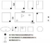
The system is mainly composed of vehicles equipped with RFID smart license plates, data wireless transceiver nodes (RFID remote readers), CDMA modules, GIA systems, data processing units, data processing and control centers. The following figure is a schematic diagram of a vehicle positioning and speed measurement system:

Fourth, the principle of system operation
The system is based on the method of reading the RFID electronic tag to obtain the identity information of the vehicle. It uses the TODA-based multi-base station wireless positioning method to obtain the position information of the vehicle. Speed information. Each RFID license plate stores information such as the license plate number of the vehicle, the purpose of the vehicle, the maximum cargo capacity, the maximum passenger capacity, the owner’s name, and the ID number of the vehicle. According to the building characteristics and traffic flow in different regions, a certain number of data wireless transceiver nodes are installed in order to obtain the maximum utilization of resources and reduce the waste of node layout. Each data wireless transceiver node sends a command signal that has been encoded and modulated according to a certain frequency. The RFID smart license plate within the coverage of the node receives this command. After authentication, if it is correct, it will send its own UID according to the requirements of the command. In the past, data wireless transceiver nodes received this information, demodulated and decoded it to obtain the vehicle identity information, sent it to the data processing unit through the CDMA module, and then sent it to the city data processing and control center by the data processing unit. The method based on multi-base station wireless positioning is that the wireless data transceiver node actively obtains the vehicle position information, and uses the received signal strength (RSSI), time of arrival (TOA), and time difference of arrival (TDOA) to locate. In the first step of the estimation process, the robust estimation method can be used to reduce its influence on the estimated value.
On the basis of the first estimate, find the 3 wireless data transceiver nodes closest to the RFID smart license plate, and use the TDOA values of these 3 nodes for the second positioning, so as to obtain the position information of the vehicle and transmit it to the data The processing and control center, the data processing and control center can roughly describe the trajectory of the vehicle based on the information obtained. By real-time estimation of the Doppler frequency shift generated by the movement of the vehicle, data processing can perform real-time speed measurement of the vehicle.
[ad_2]


