RFID city moped anti-theft system solution
[ad_1]
Supai Technology combines the actual characteristics of the city, is supported by modern Internet of Things technology, communication technology and information technology, and follows the guiding principles of system advancement, safety, reliability, openness, scalability, and easy maintenance to build an electric Fast vehicle identification and trajectory tracking system.
After receiving the alarm information of the stolen electric vehicle, the public security department restores the movement track and time of the electric vehicle through the on-board electronic tag and the reader at the intersection, combined with the camera monitoring of the intersection, locates the suspect in time, solves the case quickly, and improves the satisfaction of the public Spend.
System principle
The electric vehicle intelligent management system of Supai Technology is supported by the main computer of the public security monitoring center under the support of the system software, through the data transmission interface and the dedicated network, to the intersection in real timeReaderCarrying out data inspection and information collection, the reader will automatically collect the information of the vehicle tags within the effective recognition distance, and according to the system instructions, the relevant data will be transmitted to the monitoring center through the transmission network. After the data information is analyzed and processed, the dynamic distribution of electric vehicles can be reflected in the main computer interface in real time, so as to realize the monitoring of the operation status of electric vehicles on the road and realize the purpose of digital management of electric vehicles.
Following the principle of “unified card issuance, unified equipment, and unified management”, the vehicle label shall be fixedly installed when the license plate is issued, and the “one vehicle, one card” system shall be implemented.
According to monitoring needs, install readers at urban intersections and form a complete communication line through a dedicated network or wireless network.
System logical architecture and application framework
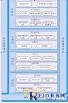
According to the system business requirements and process design, the urban electric vehicle intelligent management system is structured by four layers: perception layer, network layer, support layer and application layer, and is constructed of safety assurance system, construction and operation assurance system, and standard specification system. Security system.

System application block diagram

System functions
Real-time vehicle dynamic display
Query and display the number and identity of electric vehicles at a certain intersection on the road at any time.
Query the current actual position and movement trajectory of one or more vehicles.
Recording a series of information about the arrival/departure time and total working hours of patrol vehicles at any location can urge and confirm whether important patrol personnel conduct on-site patrols on time and at points, and reduce incidents.
Multi-point sharing of information
The system central station and network terminal can be networked to run, so that all terminals on the Internet can share information at multiple points within the scope of use authority, allowing multiple departments and leaders to share monitoring information, system comprehensive analysis information, and query various data or reports at different locations at the same time .
Rich map function
Support multiple graphics formats. Fully supports real-time multitasking.
Timely tracking function after theft
Once a vehicle is stolen, the monitoring center can immediately display the location and trajectory of the stolen vehicle, and through the linkage with video surveillance, the suspect can be locked in time.
Reader emergency function
When the intersection reader loses contact with the monitoring center, it can still work independently and automatically store vehicle monitoring data.
System performance characteristics
Powerful system processing capability
Use the LH scheduling algorithm to optimize the data processing capacity of the system;
Highly automated, automatic monitoring, statistics, and analysis of information, without human intervention in the whole process;
Geographic information display and query system based on GIS technology;
Complete data analysis capabilities;
Excellent recognition performance
System operating frequency: 2.45GHz
Identification card transmission power: 0dBm~-20dBm;
Receiving sensitivity: -80dBm;
Maximum displacement speed: the maximum travel speed of the card-carrying vehicle: not less than 80km/h;
Number of concurrent identifications for a single device: no less than 500;
Missing reading rate: not more than 10-5;
Maximum inspection cycle: no more than 30s;
Screen response time: The response time for calling up 85% of the entire screen is no more than 2s, and the rest of the screen is no more than 5s.
Two-machine switching time: The time from the failure of the working host to the normal working time of the standby host is not more than 5 minutes.
Battery life: built-in non-rechargeable lithium battery in the vehicle tag, continuous working life is not less than 3 years.
Site advantage
Environmental adaptability: waterproof and dustproof; high anti-interference, no special requirements for various interference sources and perimeter environment;
Installation convenience: sensor integrated structure design, no need for external antenna or ground sense;
Operational reliability: The internal circuit is highly integrated, and the device failure rate is minimized.
[ad_2]


