[ad_1]
1. Overview of GPS forest protection inspection system
This system is to provide forestry protection departments with a patrol management system for fire prevention, theft prevention, and pest prevention. Through GPS global positioning technology and GIS geographic information, it can implement strict and standardized management of forest rangers’ fire prevention, theft prevention, and pest prevention work. Automatically or manually report information through GPS patrol device (Android mobile phone), and support taking photos and videos. It can timely feedback to the management center various events found during the inspection process, and indicate the accurate longitude and latitude, which will endanger the forest management and protection. In the event of personnel and life safety emergencies, it can send an emergency signal to the police with one button, indicating the accurate latitude and longitude, and provide rescue personnel with accurate geographic location. And it can complete powerful functions such as the forestry bureau’s self-defining inspection area, inspection route, inspection time, inspection personnel, scheduling plan, network query, remote management and remote transmission, etc. It is simple and convenient to use, and it can be used without any operation. Complete forest inspection work.
2. The composition of GPS forest protection inspection system
GPS forest protection intelligent inspection system is composed of server, GPS inspection device, GSM network, GIS geographic information, forestry inspection management system.
3. Features of GPS forest protection inspection system
1. Automatically receive positioning information, and there is no need to lay out the work site, so it can save huge on-site engineering construction and maintenance costs.
2. The GPS positioning inspection management system uses the existing mature GSM public network for data communication. There is no need to build a communication network, and there is no daily maintenance of the communication network, making a low investment in network construction costs.
3. With the function of automatically uploading information, the current location and inspection status can be uploaded in real time.
4. The basic functions of the handheld terminal of GPS forest protection inspection system:
The GPS forest protection inspection system is very compatible and supports Android 2.3 or higher system platforms, making it a professional inspection device, without any requirements for mobile phone brands, models, and communication operators. The inspection device is used in conjunction with the forestry inspection system, and the GPS satellite positioning accuracy is within 2-10m.

1. User authentication
2. Fully automatic mode inspection, no need for human management during inspection process
3. Automatically obtain inspection tasks and related data
4. It can work normally when there is no signal, and the data will not be lost. After the signal is normal, the data will be uploaded automatically without management.
5. Obtain satellite signals automatically, collect, record, and upload position coordinates
6. Collect the patrol site situation with text description, photos, and videos
7. Automatically record the inspection process (inspection time, personnel, trajectory, area)
8. One-key alarm by category in emergencies
9. Check the management and protection area and current location on the electronic map at any time
10. Check the company notice announcement
11. Full voice broadcast
Five, GPS forest protection inspection system management platform function introduction
1. There is no need to install the query terminal, you can log in to view management on mobile phones, tablets, and computers
2. Personnel information management
3. Level management authority
4. Ranger management and protection area management
5. Assignment of inspection tasks
6. Import of forest distribution map
7. Receive alarm signals in real time
8. Fence management
9. Information labeling of fire-prone areas, water source areas, and key inspection areas
10. Real-time monitoring of the current position and trajectory tracking of the ranger on the electronic map
11. Historical track query
12. Power statistics
13. Check the patrol site situation, command and handle the incident, save it in files, and facilitate later retrieval.
14. Automatic analysis and statistics of inspection data
15. Automatic assessment and inspection work, and generate various assessment reports, support exporting and printing.
16. Send internal notifications to the company
6. The effect of GPS forest protection inspection system after use
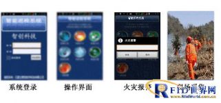
1. Ranger: Don’t underestimate this mobile phone. It is directly connected to the monitoring system of the Forestry Bureau. In case of an emergency, you can click the alarm button to notify the Forestry Bureau. Speed to deal with accordingly. However, whether you are on the job or not, through this system, the forestry authority can also see clearly.
2. Forestry Bureau: The staff only need to open the GPS forest protection patrol system and move the mouse, and the information such as the patrol route, speed and geographic coordinates of the forest ranger can be clearly visible. The staff said that with the GPS forest protection patrol system, the forest ranger and forest protection situation can be kept informed in the office. At the same time, it can also dispatch, supervise and manage the on-duty situation of forest rangers in a timely manner to ensure that the forest rangers patrol on their posts.
3. Accident handling: “Yicheng found fires, landslides and other accidents” can use the forward photos and videos returned by the forest rangers, and the forestry department can get the accurate location and situation of the accident site in the shortest time, and make the corresponding response in the first time deal with. Sudden accidents are reported as soon as they are reported, and the use of GPS forest protection inspection system establishes a brand-new and solid technological protection barrier for forest resources.
Display of the use effect of the management platform:
1. Load the effect of the management and protection area

2. Historical trajectory effect

3. Check the scene

4. Alarm response processing
5. Itinerary statistics
6. Comparison of handheld effects

[ad_2]